On a tight timeline, and with some brilliant minds and technology, we recently wrapped up an important client project.
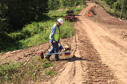
In Colorado, one of RETTEW’s energy clients owns many miles of underground pipeline.
After a recent incident in the state, the governor ordered inspections of all underground flow lines within 1,000 feet of occupied buildings.
To keep businesses and residents safe, those pipelines need to be thoroughly identified and mapped out. The information must then be made available to the state for any development or digging that may occur.
RETTEW’s client needed rapid response documentation of their underground assets.
Under a typical timeline, RETTEW’s Subsurface Utility Engineering group investigates using technology such as ground-penetrating radar, electromagnetic locators, and M scope tools. The damage prevention experts then bring the data to our GIS group, which uses the information to compose digital maps for viewing.
 Given the quick turnaround needed in this situation, RETTEW’s GIS specialists did what we do best: rethink project challenges to identify a clearer, more efficient path. Instead of taking collected data and plotting on paper mapping, we implemented a live, web-based mapping tool that’s easily edited with live data.
RETTEW’s team members locating the underground pipes could see their documentation progress as they went, and quality checked the details without finding and using paper maps to compare. They could also make edits to the GIS maps while in the field, or from their desktop in an office. Instead of providing one service first, followed by the other, our SUE and GIS groups worked in tandem.
Because of the practical problem-solving of RETTEW’s GIS group and collaboration with our Subsurface Utility Engineering team, the client had comprehensive, interactive maps with all of its underground utilities within a few short weeks.
Now that’s results, when and how you need them!