 On a college campus in Western PA, it’s not only students who are adding to their knowledge base.
RETTEW’s GIS and Subsurface Utility Engineering groups are working together to help locate and map every single underground utility across the campus.
Our GIS team began by creating a campus map integrating underground plans.
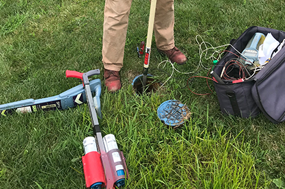
 A damage prevention specialist then used a GNSS receiver and electrical signals to locate the underground utilities. By using an ArcGIS collector and a tablet, the information is entered directly in the field.
As the site investigations continued, other staff could log in and begin to see the more comprehensive mapping coming together.
Soon, the campus physical plant will have a tool to consult for all ongoing maintenance and upgrade projects!