The strength of SUE: Using technology to find and image the unseen

The Subsurface Utility Engineering (SUE) process provides peace of mind on each project. RETTEW’s SUE team surveys, locates, and maps utilities so your construction managers and designers have a clearer picture of the subsurface utility layout. This process not only minimizes construction change orders and redesign, but it also creates a safer working environment.
SUE helps keep projects and budgets on target and unaffected by inadvertent utility conflicts or damage. With more than 20 years of experience, we are experts in locating anything underground, in walls, and in foundations. From the most complex industrial sites to sensitive campus environments, RETTEW adapts our utility locating expertise to meet the unique challenges of every project, enabling precision, safety, and efficiency across diverse landscapes and infrastructure challenges.
811 and SUE
Underground utility mapping is critical for project safety, and RETTEW has been a pioneer in 811 “Call Before You Dig” regulations since their inception. Even in states requiring 811, existing utility maps only scratch the surface—approximately 65% of underground utilities remain private and undocumented.
Our SUE process goes beyond standard mapping, comprehensively identifying both known and unknown utilities. By thoroughly investigating potential underground obstacles, we help keep projects safely on target. Our experts intimately understand underground utility mapping and are prepared to guide you through every step of the discovery process.
Subsurface Utility Engineering in practice
No utility map is perfect. In fact, most maps are rarely accurate! Often, maps are updated using old information and thus carry a legacy of inaccurate information. And there’s no worse time to realize that than in the middle of construction. It is common for a facility owner to have the proposed construction plans for the utilities, but not the as-built plans. Many changes occur between the paper plans and the actual installation of utilities that are not captured and represented in maps. Additionally, major and minor utility upgrades are frequently not added to existing maps. Unfortunately, new construction plans are commonly based on where the original utilities were supposed to be installed instead of where they actually are. RETTEW’s SUE team takes the uncertainty out of the process, providing accurate mapping and ultimately decreasing risk. Read more examples about unmapped utilities.
The breadth of geophysics and subsurface utility engineering we have performed has taken us all over the proverbial map. From military bases to government facilities, manufacturing plants, and more – we know the ins and outs of working in a variety of hard-to-access places and how to work in and around active sites. This allows your team to continue working, be productive, and stay on schedule. We provide borehole/corehole clearance surveys, vacuum excavation or potholing, ultrasonic leak detection, and closed-circuit TV (CCTV) pipe and cavity inspection services. No matter the project size or scope, our extensive expertise allows us to handle small, quick jobs as well as large, complex projects efficiently.
This wasn’t your typical high-wire act. When a client needed utility mapping of a high-pressure natural gas pipeline located in a right-of-way between two existing pipelines, they called RETTEW. Before they could begin excavation work, the client needed to adhere to PA One Call requirements to mark their assets. A portion of the right-of-way was steep terrain covered in brush and snow. This created physical and safety challenges for personnel carrying the necessary utility location equipment. Alongside our own Safety Consulting services team, the SUE team rappelled the hillside with our gear to mark out approximately 1,000 feet of pipeline. Beyond rappelling, RETTEW’s experts provided rope rescue training and certification to everyone involved. This rigorous work allowed contractors to proceed with gas line planning and excavation while adhering to state requirements. Read more about this project.
Experts at every turn
Outside of the full SUE process, RETTEW is a scalable, full-service provider. We’re here for you. Our in-house designers, construction experts, and land development planners offer a complete package for your company’s large and small engineering needs. Just need waterlines marked? We do that too.
When you choose RETTEW, you get top-level knowledge and experience. All our field crews are experts in geophysics and subsurface utility engineering with more than 15 years of experience. We are even a trusted advisor to other engineering firms that don’t offer these services. It’s what sets us apart.
The team at RETTEW is equipped with cutting-edge tools and technology: robotic cameras, optical imaging, ground penetrating radar (GPR), GIS mapping, and more. And if we discover an unexpected problem, our SUE team seamlessly engages additional on-staff geophysics expertise to dive deeper to find a solution.
Thank you for your efforts on a waterline locating project; RETTEW didn’t cut any corners. That persistence and commitment is what we need.
Solving a puzzle you can’t see
SUE helps discover potential obstacles ahead of time.
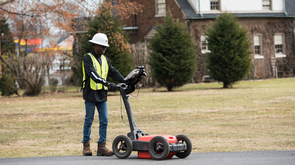
 We help you design away problems and conflicts well before construction without any disruption to the ground – no holes, no digging. More importantly, we never leave you worrying about a solution. If one group can’t solve your issue, we have someone on our team who can – including land development, geoenvironmental, and survey experts. We care about our clients and communities and go out of our way to find a solution – keeping you safe, in compliance, and on budget.
Name the problem; we have your solution.
Subsurface Utility Engineering Specialties:
Utility Design Services
- Ground Penetrating Radar (GPR)
- Interior Locating (Walls/Foundations)
- Locate Underground Storage Tanks, Non-Metallic and Abandoned Lines
- Locate Water, Sewer, Electric, Fiber, Telecom and Gas Services
- Metal Detection Surveys (EM-61)
- Subsurface Utility Engineering (SUE): Quality Levels A, B, C, and D
- Utility Services Electromagnetic (EM) Locating
- Vacuum Excavation (Air/Hydro) Services
Scanning, Inspection, and Mapping
- CCTV Push and Crawler/Robotic Camera
- Cross Bore Investigations (Sewer/Gas)
- GPS/GNSS Surveying
- Interior Locating (Walls/Foundations)
- Concrete Scanning
- Rebar Grid Patterns
- Post-Tension Cables
- Sewer and Drain Integrity Assessment
- Utility Mapping (GIS/CAD)
811 Program Management
- 811 Ticket Management/Field Locate
- Damage Investigations
- 811 Program Development, Evaluation, and Staff Training
- Veriforce Training and Certification